Computer Vision
for every application

Computer Vision
voor elke toepassing

State of the art Machine Learning Technologies to get the most out of your data.

State of the art Machine Learning Technologie om alles uit uw data te halen.

Wat wij doen

Wij bouwen slimme en bruikbare AI-oplossingen om impact te maken.

Prescription Maps for Precision Farming

Taakkaarten voor Precisielandbouw

taakkaart

Together with ABdrone we're developing models for weed detection in drone photography. The results are prescription maps which can be used for precision farming. Examples of this are spotspraying and robots that only target the weeds and not the rest of the crop and land.

At the moment we're working on the following weeds:
  • Sorrel
  • Potato Volunteers
  • Thistles
Other weeds, and custom jobs are available on request.

Our prescription maps in action:


Samen met de ABdrone ontwikkelen we modellen waarin we onkruiden herkennen in drone foto's. De resultaten zijn taakkaarten die gebruikt kunnen worden voor precisielandbouw. Denk hierbij aan spotspraying of robots die alleen de onkruiden verwijderen en de rest van de planten en land ongemoeid laten.

Momenteel werken wij aan de volgende onkruiden:
  • Ridderzuring
  • Aardappelopslag
  • Distels
Andere onkruiden, en maatwerk zijn op aanvraag mogelijk.

Onze taakkaarten in actie:


Solarpanel detection

Zonnepaneelherkenning


solar_panel

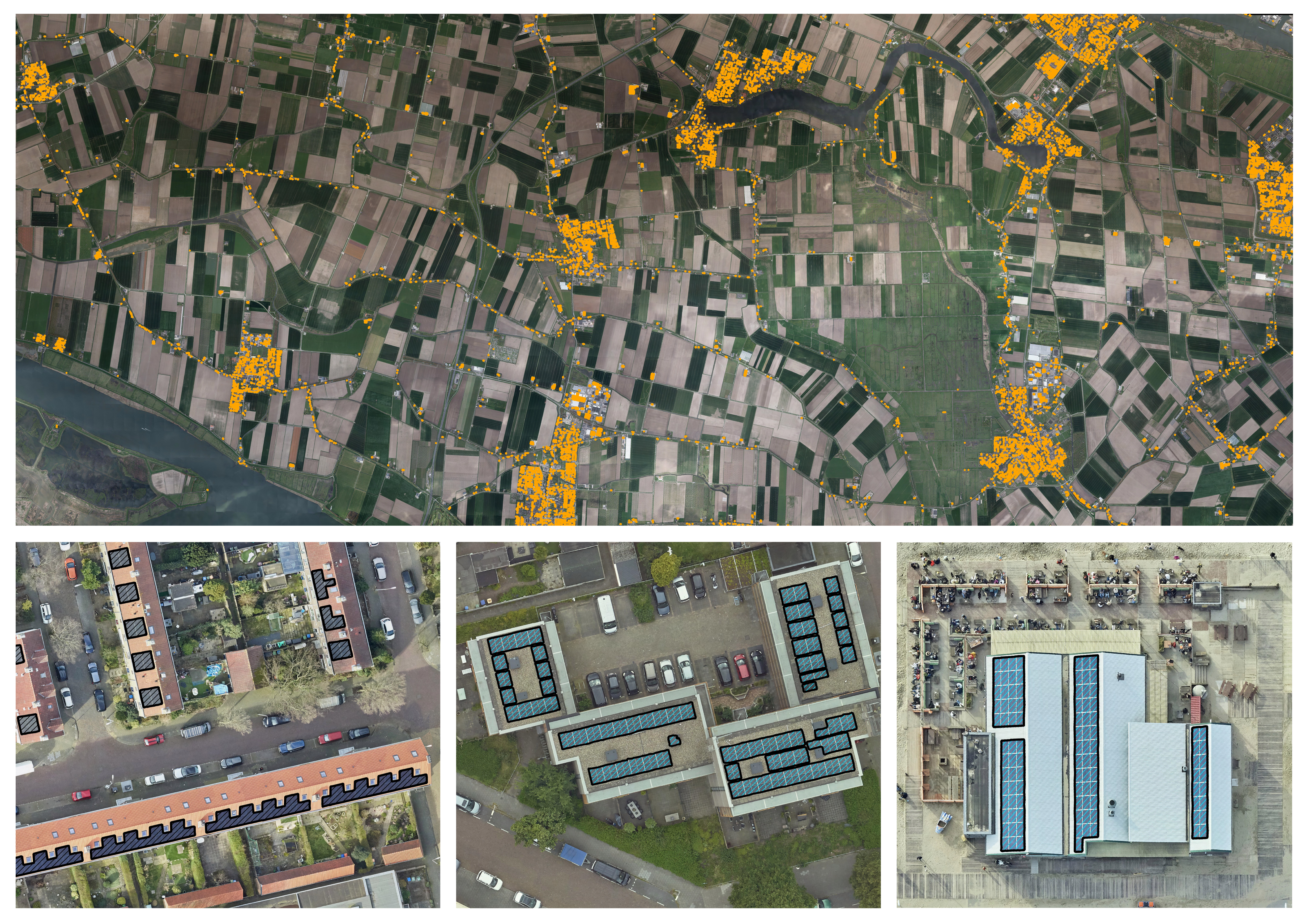
For Aerovision, we developed a system that enables large-scale recognition of solar panels in aerial photographs for various municipalities.
We combined the GPS locations of the panels with AHN (Actual Height Model of the Netherlands) data and PVGIS (Photovoltaic Geographical Information System). This allowed us to determine the angle of the panels and estimate the installed capacity.

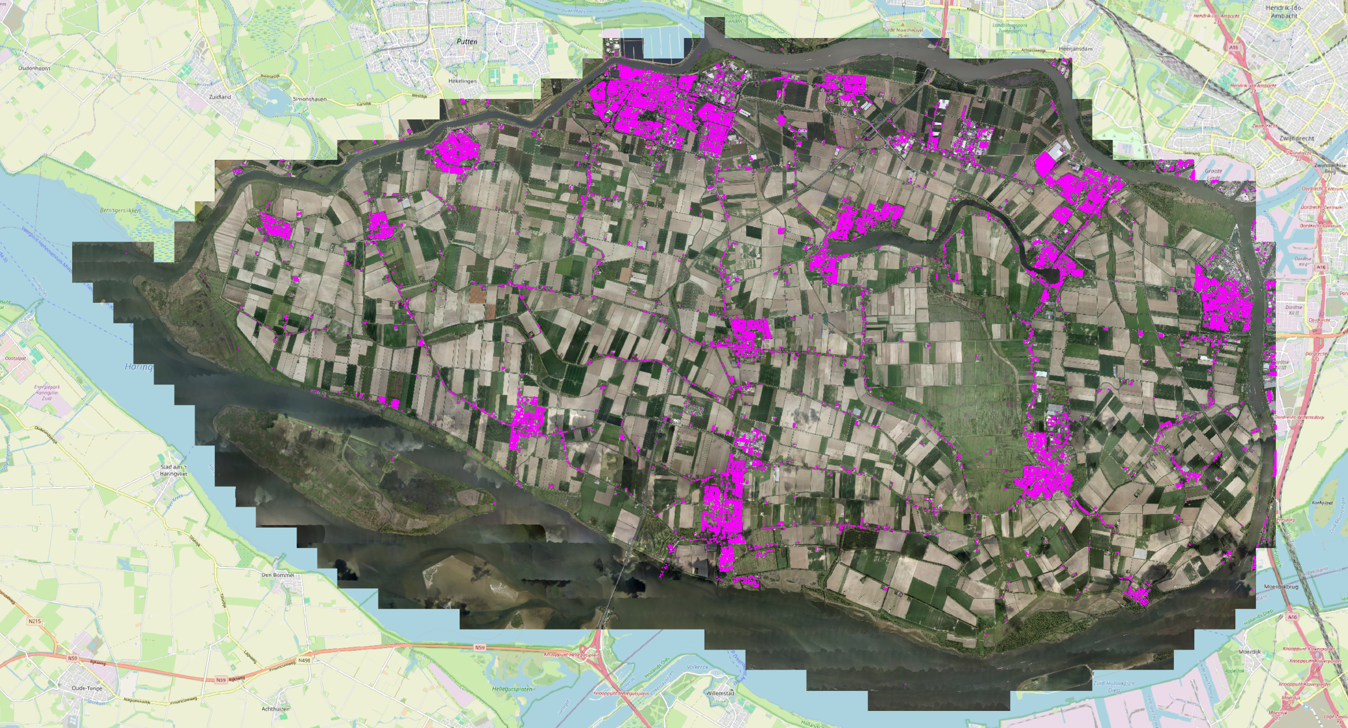
Thanks to multiple years of aerial photography, Aerovision was able to map the number of installed solar panels based on our data.

In total, we processed more than 874 km² of high-resolution data with a ground resolution of 2.5 cm for various end clients, identifying over 3 million solar panels.


Voor Aerovision hebben wij een systeem gemaakt waarbij we op grote schaal zonnepanelen herkennen in luchtfoto's voor verschillende gemeenten.
De GPS-locaties van de panelen combineerden we met AHN (Actueel Hoogtebestand Nederland) data en PVGIS (Photovoltaic Geographical Information System). Hierdoor konden we de hoek van de panelen bepalen en het geïnstalleerde vermogen benaderen.

Dankzij meerdere jaren aan luchtfoto's kon Aerovision op basis van onze data de aantallen geïnstalleerde zonnepanelen in kaart brengen.

In totaal hebben we meer dan 874 km² aan hoge resolutie data met een grondresolutie van 2,5 cm verwerkt voor verschillende eindklanten en hierin meer dan 3 miljoen zonnepanelen herkend.

hoeksewaard


Demo of classifying birds in drone imagery

Demonstratie van vogelherkenning in drone fotos


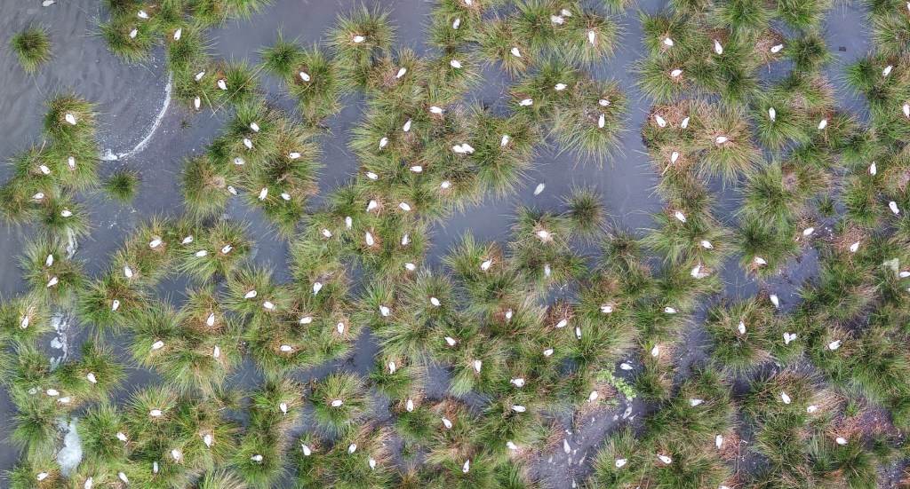
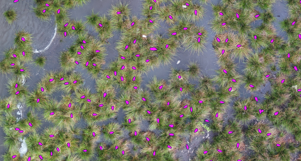
Move the slider to see the detections.

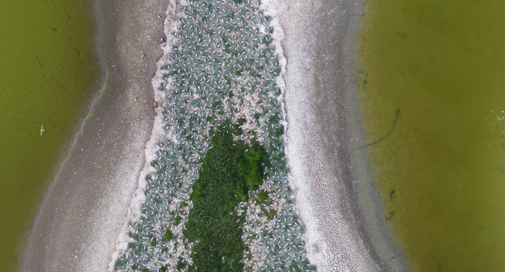
Together with Fieldwork Company and the Rijksuniversiteit Groningen we worked on a model that discriminates terns from seaguls (which look very similar when photographed from above with a drone). With this technology we can count the number of each species of birds in an area/colony, on which the researches can base their statistics.
Beweeg de slider om de detecties te zien.

Samen met de Fieldwork Company en de Rijksuniversiteit Groningen hebben we gewerkt aan een model dat onderscheid maakt tussen sterns en zeemeeuwen (die van bovenaf op drone foto's erg op elkaar lijken). Met deze technologie kunnen we vogelsoorten snel tellen in een gebied of kolonie.


Camera Trap Management Solutions

Camera Trap Management Oplossingen

TRAPCAM-Aid
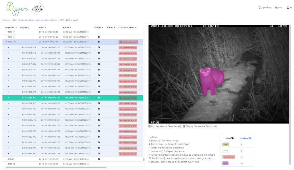
Wildlife Interactive Labeling Database (WILD) camera management system
TRAPCAM-Aid is an interactive camera trap database with ~1.82 milion photos, GPS info, and built-in animal detection developed for Ecosensys and Jasja Dekker.

One key feature is combining animal detections across photo bursts into composites, for 10x faster photo analysis.


 Report - Monitoring kleine marterachtigen provincie Fryslân 2021

TRAPCAM-Aid is een interactive cameraval database met ~1,82 miljoen foto's, GPS informatie en ingebouwde dieren detectie, ontwikkeld voor Ecosensys en Jasja Dekker.

Een unieke functie is het combineren van dierdetecties in foto-opnames tot composities, voor een 10x snellere fotoanalyse.


 Rapport - Monitoring kleine marterachtigen provincie Fryslân 2021


Drone stitches & GIS integration

Drone stitches & GIS integratie

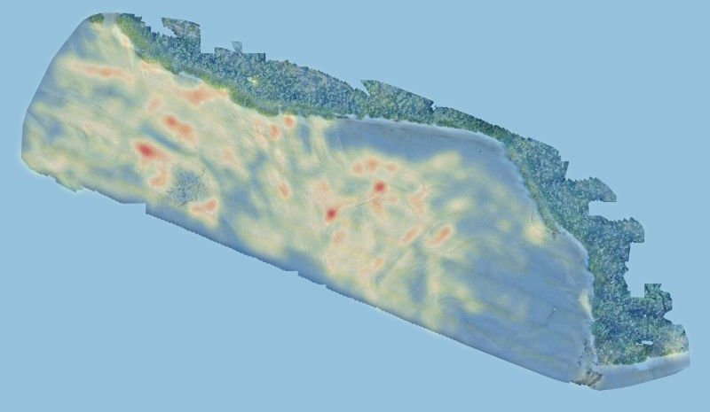
Ray pits
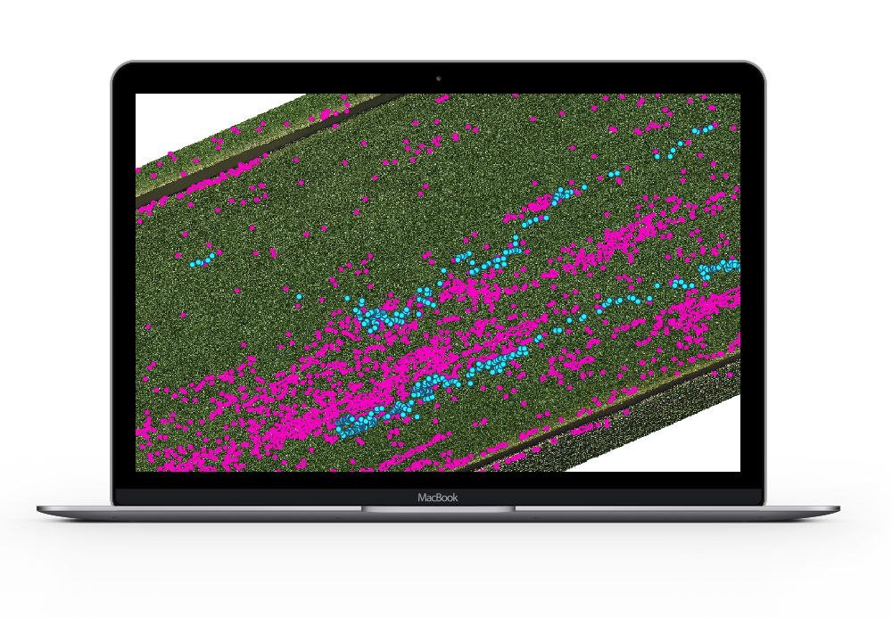
We developed frameworks for object detection in large GeoTIFF files and support exporting results as GIS shape files.

This demo is a heatmap of raypit detections at an island in Guinee-Bissau, postprocessing is done in QGIS. The projects is done together with Guido Leurs of the Rijksuniversiteit Groningen, and the Drone flights were performed by Fieldwork Company
We hebben een framework voor objectherkenning in grote GeoTIFF bestanden gebouwd, deze ondersteunt onder andere het exporteren van de resultaten naar GIS shape files.

Deze demo laat een heatmap zien van raypit detecties bij een eiland in Guinee-Bissau, postprocessing is gedaan in QGIS. Dit project is uitgevoerd samen met Guido Leurs van de Rijksuniversiteit Groningen, en de drone vluchten zijn uitgevoerd door de Fieldwork Company


Machine Learning Assisted Labeling

 Label Studio
Label Studio
Fast Machine Learning assisted labeling powered by Label Studio.

Labeling is a crucial labor-intensive step, that we can speed up significantly. While you annotate, our custom Machine Learning backend will adaptively learn your annotations and it will provide you with suggestions, significantly accelerating your workflow.

Another advantage: while labeling, you will get a preview about Machine Learning model performance on your data.
Snel Machine Learning ondersteund data annoteren met Label Studio.

Data annoteren is een cruciale arbeidsintensieve stap waarop wij een grote tijdsbesparing kunnen leveren. Een door ons op maat gemaakt Machine Learning backend kan adaptief meeleren tijdens het annoteren. Deze zal u suggesties gaan geven en uw workflow aanzienlijk versnellen.

Nog een voordeel: Tijdens het annoteren geeft het systeem inzicht in hoe goed het model presteert op uw data.


Tailored Solutions

Maatwerk Oplossingen

Leaflet

We develop custom tailored solutions for object detection, data analysis, and visualization.
An interactive bird detection map is available here

Wij leveren maatwerk oplossingen voor objectherkenning, data anlyse en visualisatie.
Een interactieve kaart met vogelherkenning is hier beschikbaar

About the team

Over ons


Jelle Dalenberg, PhD

Researcher & Developer

Jelle holds a master's degree in Human-Machine Communication and a PhD in neuroscience. With a strong interest in Machine Learning, statistics, and practical solutions for scientific and methodological challenges, he combines his work at Objectherkenning.com with a part-time staff position as a bioinformatician in the Department of Pathology & Medical Biology at UMC Groningen.

Jelle heeft een master in Human Machine Communication en een PhD in neurowetenschappen. Met een sterke interesse in Machine Learning, statistiek en praktische oplossingen voor wetenschappelijke en methodologische vraagstukken, combineert hij zijn werk bij Objectherkenning.com met een deeltijd stafpositie als bioinformaticus bij de afdeling Pathologie & Medische Biologie in het UMC Groningen.

Lude Feldbrugge, Msc

Researcher & Developer

Lude earned his master's degree in Artificial Intelligence (specializing in Reinforcement Learning) and as an entrepreneur applies Machine Learning to solve practical problems across various domains. With his broad technological interest and hands-on approach, he bridges knowledge fields and creates innovative solutions.

Lude behaalde zijn master in Kunstmatige Intelligentie (specialisatie Reinforcement Learning) en richt zich als ondernemer op het toepassen van Machine Learning voor praktische problemen in diverse domeinen. Dankzij zijn brede technologische interesse en hands-on aanpak overbrugt hij kennisvelden en creëert hij innovatieve oplossingen.

Contact

Objectherkenning.com

Location: the Netherlands (Eelde, Groningen)

Tel:

Mail: